The landscape formation in Heumensoord has been determined by sedimentation of rivers and the presence of ice sheets during the Saalian, about 200 000 to 125 000 years ago. After an interglacial period called Eemian, another period of extreme cold followed during the Weichselian, but this time without invasion of the land by ice in this region. From about 10 000 years ago on, the temperature began to raise again.
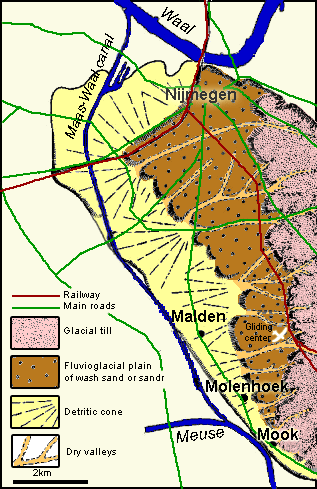
| Glacial till and soil sedimentation (Heumensoord-Malden-Mook-Groesbeek) |
 |
 |
|
Source: "Geologische/Geomorfologische waarden", Bos en Kuil (according to D. Teunissen and A. Kempers; used with permission)
|
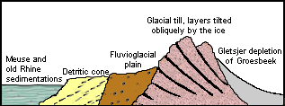
Impact of the ice sheet in the Saalian
In the Saalian (forelast glaciation; ± 200 000-125 000 years ago; see also
general geology) a hundreds of meters thick package of ice pushed forward from Scandinavia to the south. The end front reached the present surroundings of Nijmegen.
Tongues of ice sheets stowed a mixture of sediments of the Rhine and Meuse with moraine material carried by the ice sheets, some all the way from Scandinavia, to a more than hundred meter high glacial till. Due to the barrier of ice, Meuse and Rhine could not flow any more to the north. The Rhine formed then the still broad valley of the later Niers river. Meuse and Rhine were driven to each other at the level of Gennep and the two rivers were forced to bow to the west in the direction of the current Dukenburg and Berendonck area in a wild pattern of streams.
Formation of Sandr after the Saalian
When the ice began to draw back melt water ran over the glacial till and carried a lot of material to lower parts. The washed away sand was deposited in the shape of a plain with a shallow-slope, the so-called
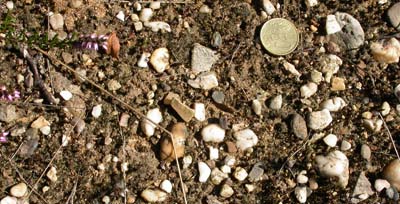
Sandr plain, on the west side just outside the glacial till: such sedimentation is called fluvio-glacial (river and ice) or melting water sedimentation. A strongly layered sedimentation package up to 30 meter high, which consisted of coarse to fine sand altered with banks of gravels containing rests of Scandinavian granite (igneous rock containing quartz, alkali and plagioclase feldspar) by the ice. A part of the surface of Heumensoord, among which the glicing center Malden, but also constructed areas in Molenhoek, the Grote Lier (the open area between Malden and Molenhoek), the Maldensvlak, the Elshof and south-Nijmegen lay on this Sandr-plain. In western direction this flat area ends in a quite abrupt "step" which probably arose from side-wards erosion by the Meuse and Rhine water: here the rivers streamed along the hills of the glacial till, in particular in the area between Mook and Plasmolen at the level of the Sint-Jansberg, and washed away the sand of this glacial till and carried it right away. Due to erosion the height of the glacial till has decreased significantly since the Saalian.
Permafrost during the Weichselian
During the last glacial period, the Weichselian (± 115 000-12 000 years ago), the ice sheet did not reach the present area of the Netherlands again. However, in the mid-Weichselian there were very cold and wet periods which caused here a polar desert landscape. The underground remained frozen, also in summer time; this is called "permafrost". Over this hard and impermeable layer, in summer time, water of melted ice and snow streamed through furrows to the lowest parts. The washing away was amplified by stagnant water that could not penetrate through the frozen soil and that slowly carried aways mud material down the hill. The process in which a stream of mud glides over a slope is called "solifluction". In contrast to the fluvio-glacial sedimentation the solifluction material is not layered. The sandy material that was washed away from those valleys was deposited as detritic cones over part of the fluvio-glacial plain, among others in the area around the Mulderskop.
Post-glaciation climate warming
After the deeper underground had thawed following the last glacial, the water could easily sink through the layers of sand and gravel. Nowadays one finds these former ways for water discharge back in the landscape as dry valleys. They show a characteristic approximately perpendicular orientation relative to the main direction of the glacial hills as they protrude from the hills to the earlier formed fluvio-glacial plain on the westside of the tills. Examples of such dry valleys are the track where the former railway Nijmegen-Kleef runs (although it has been deepened when the rail was laid), the Kraaiendal (north of the Maldensebaan), the Startsedal near the Mooker moore and the deep valley in the prolongation of the Hendrik van Nassaulaan in the Bisselt.
The fluvioglacial plain is limited and crossed at the west side by old and recent sedimentation of clay and river sand from the great rivers. The closer to the Meuse the more clay is found in the sandr soil.
Influence of man on the development of the landscape
Since the last glaciation about 10 000 year ago, the climate has becomen milder and also the vegetation and landscape have been developing to a more stable system. The climax vegetation for this region is a Oak-Birch wood (Querco-betuletum).
In the time that the Romans had settlements in this area, a road has been laid across Heumensoord, which connected Noviomagus (Nijmegen) via Ceuclum (Cuijk), Blariaco (Blerick) with Atuatuca Tungrorum (Tongeren). In the middle of Heumensoord one can still find the remains of a true Roman Legion highway road and a guard gate, nowadays still visible as an in elevation in het landscape (More on this
Roman road).
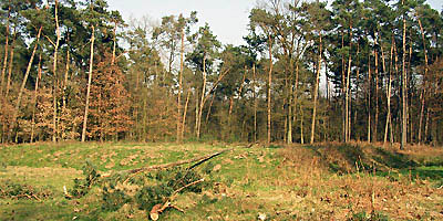
From the early middle-ages the use of wood increased, fields were reclamed for agriculture and (over)grazing occured.and the reclamation of fields, on until the nineteenth century., Due to these activities of man, the woods partly disappeared. They were replaced by a moore vegetation dominated by Heather (Calluna vulgaris). In het beginning of the forelast century part of the "wild" heather fields were taken in use as culture grounds to grow crop in little fields or to plant trees for the production of wood. Many of those grounds were planted with Pine trees, Corsican Pine and Summer Oaks, respectively Pinus sylvestris, Pinus nigra and Quercus robur. However, some areas remained covered by by moore and grass, especially in areas with poor soil like on the site of the present gliding field. In recent years due to wood cutting and a new resource management the area covered by moore is increasing again. (More on the vegetation).
Sources
This page is based on the archive of abide dr. D. Teunissen and on additional text and figures by drs. AJ Kempers from the article "Geologische/Geomorfologische waarden" posted on the website
Bos en Kuil (arranged with permission).


