Geology en hydrology Ooijpolder |
||
Saalian-glaciation, warmer Eemian and cold WeichselianDuring the Saalian glaciation (about 240 000 year ago) the present area of the Ooijpolder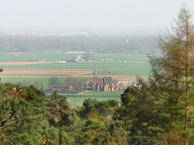 was just within the limit of the area covered by the ice sheets (map of the Saalian glaciation). The rivers were driven southward by the shifting ice mass. was just within the limit of the area covered by the ice sheets (map of the Saalian glaciation). The rivers were driven southward by the shifting ice mass.
During the warmer Eemian (128 000 until 116 000 years ago) which followed the Saalian, the tongues of the ice sheets melt. The Niers valley and the common Rhine-Meuse valley received a major flow of meltwater to discharge. At the foot of the terminal moraine alluvian cones of gravels, sand and loam particles, so-called Sandr plains, were formed. The level of the Rhine water continued to raise against the glacial shores south-east of the present location of Nijmegen until it broke through the till. As a result, the Rhine recovered its original trajectory flowing north of the Nijmegen glacial till, but it still remained south of the Montferland and the Veluwe tills. Along the rivers sedimentation occurred. (More about the general geology). After the Eemian came the Weichselian (116.000-12.000 years ago),the last clear glacial that our earth has known so far. During that glacial the current Netherlands and Belgium were not covered by ice, but the sea level dropped again and periods of severe cold (polar desert) were alternated with a little less harsh (tundra) conditions. Extremely cold, prepoundarily west winds carried sedimentation material from the Southern North Sea basin and deposited it at the lee-side of the glacial tills, at the north-east side of present Nijmegen.
The HoloceanIn the Holocean (begonnen about 12000 years ago and still in process) the temperature and the sea level raised,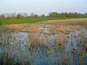 the precipitation increased and the great rivers carried a lot of sediments to their lower parts. Besides, small plants, bushes and also trees reappeared, while man began te have more and more influence on the landscape. In the region corresponding to the Ooijpolder, due to frequent floodings, sand and sablon (mixture of clay and sand) were deposited on the river banks, while at greater distance from the summer bedding where the stream was slower, sludge sank to form clay soil. This transition in the composition of the soil can still be found at present time: sand and gravel (among which little pabbles carried from the Alps) along the Waal and thick layers of heavy clay at the foot of the glacial till, with the best part for agriculture in the fertile middle ribbon. the precipitation increased and the great rivers carried a lot of sediments to their lower parts. Besides, small plants, bushes and also trees reappeared, while man began te have more and more influence on the landscape. In the region corresponding to the Ooijpolder, due to frequent floodings, sand and sablon (mixture of clay and sand) were deposited on the river banks, while at greater distance from the summer bedding where the stream was slower, sludge sank to form clay soil. This transition in the composition of the soil can still be found at present time: sand and gravel (among which little pabbles carried from the Alps) along the Waal and thick layers of heavy clay at the foot of the glacial till, with the best part for agriculture in the fertile middle ribbon.
Prehistorical landscapeThe prehistorical landscape of the fluvial area must have shown a big diversity: islands and plains with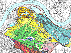 fertile and poor soils, swamps, gravel banks, dunes, meadows and various types of woods: in the frequently flooded lowlands and in lows with seepage riparian forest with soft woods like Willows and Black Poplars, and on the drier grounds like floodbanks hard wood species (e.g Elm, Ash, Hawthorn, Blackthorn and Oak; remnants of >8000 years old oak trunks can be seen in the Millingerwaard). And then, there was everywhere plenty of water. The delta of the Rhine has known changes in course during its post-glacial history, with the formation of deep channels, in particular the bifurcation in Nederrijn (Lower Rhine) and Waal, and many distributaries. Old river arms, like the outer-dike Oude Waal near Nijmegen, a meander from the 17th century, and the Ooijsche Graaf, a bow over Erlecom, the present Ooijse Graaf and the village Ooij, or old Rhine beddings east of the Pannerdens Canal (zie de geomorfological map on the website of the municipality Ubbergen). fertile and poor soils, swamps, gravel banks, dunes, meadows and various types of woods: in the frequently flooded lowlands and in lows with seepage riparian forest with soft woods like Willows and Black Poplars, and on the drier grounds like floodbanks hard wood species (e.g Elm, Ash, Hawthorn, Blackthorn and Oak; remnants of >8000 years old oak trunks can be seen in the Millingerwaard). And then, there was everywhere plenty of water. The delta of the Rhine has known changes in course during its post-glacial history, with the formation of deep channels, in particular the bifurcation in Nederrijn (Lower Rhine) and Waal, and many distributaries. Old river arms, like the outer-dike Oude Waal near Nijmegen, a meander from the 17th century, and the Ooijsche Graaf, a bow over Erlecom, the present Ooijse Graaf and the village Ooij, or old Rhine beddings east of the Pannerdens Canal (zie de geomorfological map on the website of the municipality Ubbergen).
When man cameIn the earliest time, man has settled on the natural sandy bumps formed as local river dunes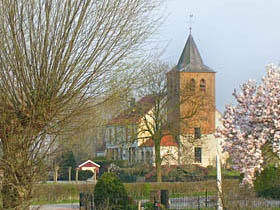 (called "donken" in Dutch; an example is the place Persingen) at the end of the glacial period. The early inhabitants lived as hunters (remnants of deers and bevers were found in prehistorical camps). Then, in the course of history people have built themselves elevations (called "pollen" or "terp" in Dutch) for housing and as refuges for floods. In the current landscape one can still recognize those natural or artificial 'heights' dominating the fields, i.e. the sandy ridge on which the village of Persingen and its church were constructed (see also Videoclip) or single farm houses, like "De Plak". More information on monuments and buildings in the landscape). (called "donken" in Dutch; an example is the place Persingen) at the end of the glacial period. The early inhabitants lived as hunters (remnants of deers and bevers were found in prehistorical camps). Then, in the course of history people have built themselves elevations (called "pollen" or "terp" in Dutch) for housing and as refuges for floods. In the current landscape one can still recognize those natural or artificial 'heights' dominating the fields, i.e. the sandy ridge on which the village of Persingen and its church were constructed (see also Videoclip) or single farm houses, like "De Plak". More information on monuments and buildings in the landscape).
From the early Middle-Ages on dikes were built as a protection against the floods of the river. 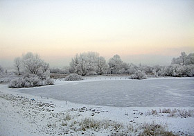 The dikes separated the relatively dry inner-dike area from the floodplains ("uiterwaarden") that are frequently submerged in winter and spring when (snow) meltwater and rain are drained. Together with the protection by dikes the land became accessible through two east-west running roads, while resources like clay grounds and woods were gained, which began to modify the landscape. Outside the dike the river continued to deposit layers of sand and clay, as well in the lower as in the higher parts of the floodplains. Only at high flood the water was let into the polder. In this way relatively fertile fine soil material sedimented, which was advantagous for the productivity of the land, especially for the production of hay. With the introduction and use of artifical fertilizers, "river fertilization" became obsolete and too much a source of troubles. After 1929 no more 'controled' inundations of the Ooijpolder have been performed. The dikes separated the relatively dry inner-dike area from the floodplains ("uiterwaarden") that are frequently submerged in winter and spring when (snow) meltwater and rain are drained. Together with the protection by dikes the land became accessible through two east-west running roads, while resources like clay grounds and woods were gained, which began to modify the landscape. Outside the dike the river continued to deposit layers of sand and clay, as well in the lower as in the higher parts of the floodplains. Only at high flood the water was let into the polder. In this way relatively fertile fine soil material sedimented, which was advantagous for the productivity of the land, especially for the production of hay. With the introduction and use of artifical fertilizers, "river fertilization" became obsolete and too much a source of troubles. After 1929 no more 'controled' inundations of the Ooijpolder have been performed.
However, the majority of the floods during history were not wanted at all! 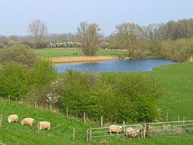 Repeatedly, the pressure of high water or ice floes became so high that dramatic breaches occurred in the soaked dikes. People, cattle and wild animals drowned merciless. Sometimes whole pieces of land with houses and all were washed away, like has happened in Persingen in the 19 th century. Behind the dike breach the boiling water caused deep scour holes (boils), called "kolken", "wielen", "waaien" or "welen" in Dutch (videoclip in Dutch). Traces of such scour holes can still be seen as small pools in the landscape. After such a disaster, the "bandijk" (river dike meant to sustain the highest water level) was repaired by rebuilding a bow around the deep boil. Due to sedimentation in the course of time the river bedding became higher than the surrouding inner-dike area. Therefore it happens that seepage water ("kwelwater" in Dutch) from the river passes under the dike to the empoldered land: therefore water levels in the inner-dike scour holes follow those of the river with some delay. Repeatedly, the pressure of high water or ice floes became so high that dramatic breaches occurred in the soaked dikes. People, cattle and wild animals drowned merciless. Sometimes whole pieces of land with houses and all were washed away, like has happened in Persingen in the 19 th century. Behind the dike breach the boiling water caused deep scour holes (boils), called "kolken", "wielen", "waaien" or "welen" in Dutch (videoclip in Dutch). Traces of such scour holes can still be seen as small pools in the landscape. After such a disaster, the "bandijk" (river dike meant to sustain the highest water level) was repaired by rebuilding a bow around the deep boil. Due to sedimentation in the course of time the river bedding became higher than the surrouding inner-dike area. Therefore it happens that seepage water ("kwelwater" in Dutch) from the river passes under the dike to the empoldered land: therefore water levels in the inner-dike scour holes follow those of the river with some delay.
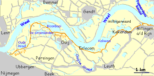
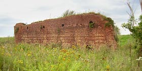 Sedimentation had another, favorable side effect forman: clay could be gained. This happened already in the Roman time at a small scale but the big flourishement of brick and roof tiles factories came in the 19th and first half of the 20th century (see videoclip about bick factories in the Ooij). Later sand and gravel were collected with big suction dredgers (i.e. the Bison and the Kali, which gave their name to the Bisonbaai and the Kaliwaal in Kekerdom). The innerdike ditches, like in the Groenlanden, are now filled with water.
De big river has many facets and own caprices that directly or indirectly still determine the life of plants, animals and man in the area of the Ooijpolder. 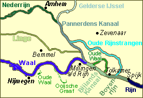 Since ever the Rhine, and with it the Waal, have been a aorta as way for transport and communication. In the eighteenth century the Bijlands and the Pannerdens canals were digged out, which now greatly serves fluvial traffic on ships, although the original plans aimed also a better regulation of the water stream aas well as defence purposes. After the industrial revolution the river became more and more an open sewage and a free cooling reservoir for Europe's growing population. Nowadays, the urge of an ecological perspective for riverland has received international attention and the quality of the water has improved since the sixties. Since ever the Rhine, and with it the Waal, have been a aorta as way for transport and communication. In the eighteenth century the Bijlands and the Pannerdens canals were digged out, which now greatly serves fluvial traffic on ships, although the original plans aimed also a better regulation of the water stream aas well as defence purposes. After the industrial revolution the river became more and more an open sewage and a free cooling reservoir for Europe's growing population. Nowadays, the urge of an ecological perspective for riverland has received international attention and the quality of the water has improved since the sixties.
Here left: Course of present and past arm of the Rhine and the Waal in East Gueldre: Rhine (=Rijn = Rhein = Niederrhein), Bovenrijn, Bijlands Canal, Waal, Oude Waal (2x), Ooijsche Graaf, old Rhine arms (Rijnstrangen), Pannerdens Canaal, Guelder IJssel and Lower Rhine (=Nederrijn) Like all big rivers the Waal has engendered a natural 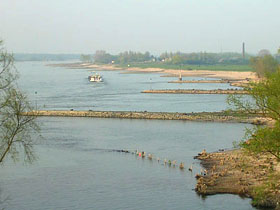 separation between people on either sides of the banks. Testimonies of this boundary can be found in main historical episodes (think for example of the heroic Waal crossing on 20 September 1944), but also on the little daily features (for example the small ferry boats which workers of the stone factories used to cross the water between the north bank and the Ooijpolder, but in fact also nowadays traffic jams at the Waal bridge). separation between people on either sides of the banks. Testimonies of this boundary can be found in main historical episodes (think for example of the heroic Waal crossing on 20 September 1944), but also on the little daily features (for example the small ferry boats which workers of the stone factories used to cross the water between the north bank and the Ooijpolder, but in fact also nowadays traffic jams at the Waal bridge).
Regarding the Ooijpolder, the chapter of water management has never been completely closed. 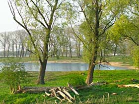 In rather recent years for example a project has passed -and disappeared- which planned to cut the meander of the Waal right through the Ooijpolder in order to improve fluvial transportation. Around 2004 a proposal came up to use the area a emergency flooding surface. With the high water levels of 1995 the inhabitants and cattle of the Ooijpolder were evacuated, because the dike showed weaknesses. Meanwhiles the dikes have been consolidated, but the consequences of global warming are a new point of concern and discussion.
In the last decades the emphasis of activities in the Ooijpolder has moved moving toward a function as natural resource and recreation. The inner-dike clay ditches flooded with seepage water and today they form a wonderful natural complex of puddles, swamps and luxuriant banks
(photo 1 and 2 taken in the Groenlanden). The Bisonbaai, located in front of the picturesque home cafe and hotel "Oortjeshekken" (videoclip in Dutch), is a favorite freely accessible recreation and swimming area with a sand beach. In the cold winters of 1997 and 2009 people scatted everywhere in undeep waters. The Ooijpolder is part of the larger natural reserve "De Gelderse Poort" to which also the Millingerwaard and the riverbanks areas around Pannerden, Lobith, Emmerich and Gendt belong. In the Ooijpolder some 260 species of birds have been observed through the years and about 500 wild plant species grow there! In rather recent years for example a project has passed -and disappeared- which planned to cut the meander of the Waal right through the Ooijpolder in order to improve fluvial transportation. Around 2004 a proposal came up to use the area a emergency flooding surface. With the high water levels of 1995 the inhabitants and cattle of the Ooijpolder were evacuated, because the dike showed weaknesses. Meanwhiles the dikes have been consolidated, but the consequences of global warming are a new point of concern and discussion.
In the last decades the emphasis of activities in the Ooijpolder has moved moving toward a function as natural resource and recreation. The inner-dike clay ditches flooded with seepage water and today they form a wonderful natural complex of puddles, swamps and luxuriant banks
(photo 1 and 2 taken in the Groenlanden). The Bisonbaai, located in front of the picturesque home cafe and hotel "Oortjeshekken" (videoclip in Dutch), is a favorite freely accessible recreation and swimming area with a sand beach. In the cold winters of 1997 and 2009 people scatted everywhere in undeep waters. The Ooijpolder is part of the larger natural reserve "De Gelderse Poort" to which also the Millingerwaard and the riverbanks areas around Pannerden, Lobith, Emmerich and Gendt belong. In the Ooijpolder some 260 species of birds have been observed through the years and about 500 wild plant species grow there!
Sources and extra reading
|
||
